
Sandpoint council approves proposed reduction to city’s area of impact
By Zach Hagadone
Reader Staff
Members of the Sandpoint City Council voted May 7 to approve a proposed adjustment to the city’s area of impact, reducing it from the current 12.3 square miles to 3.4 square miles.
Council President Deb Ruehle, along with Councilors Joel Aispuro, Justin Dick, Pam Duquette and Kyle Schreiber, agreed to forward the proposal to the board of Bonner County commissioners, which will make the final decision on shrinking Sandpoint’s area of impact. Councilor Rick Howarth was the sole dissenting vote, saying that while he was pleased to see the city reduce its area of impact, he found the new proposed boundary “arbitrary.”
“Why is it as large as we are proposing today?” he said. “It feels very random the way that we’ve drawn it.”
The reduced area of impact follows a law change passed by the Legislature and approved by Gov. Brad Little in 2024 aimed at limiting the amount of power cities have to grow into their surrounding counties. As Planning and Community Development Director Jason Welker told members of the Planning and Zoning Commission on March 18, when P&Z unanimously recommended approving the new area of impact, “In fact, there’s no jurisdiction for cities within the areas of impact — this is a pure planning exercise. It’s about envisioning potential future expansion or growth.”
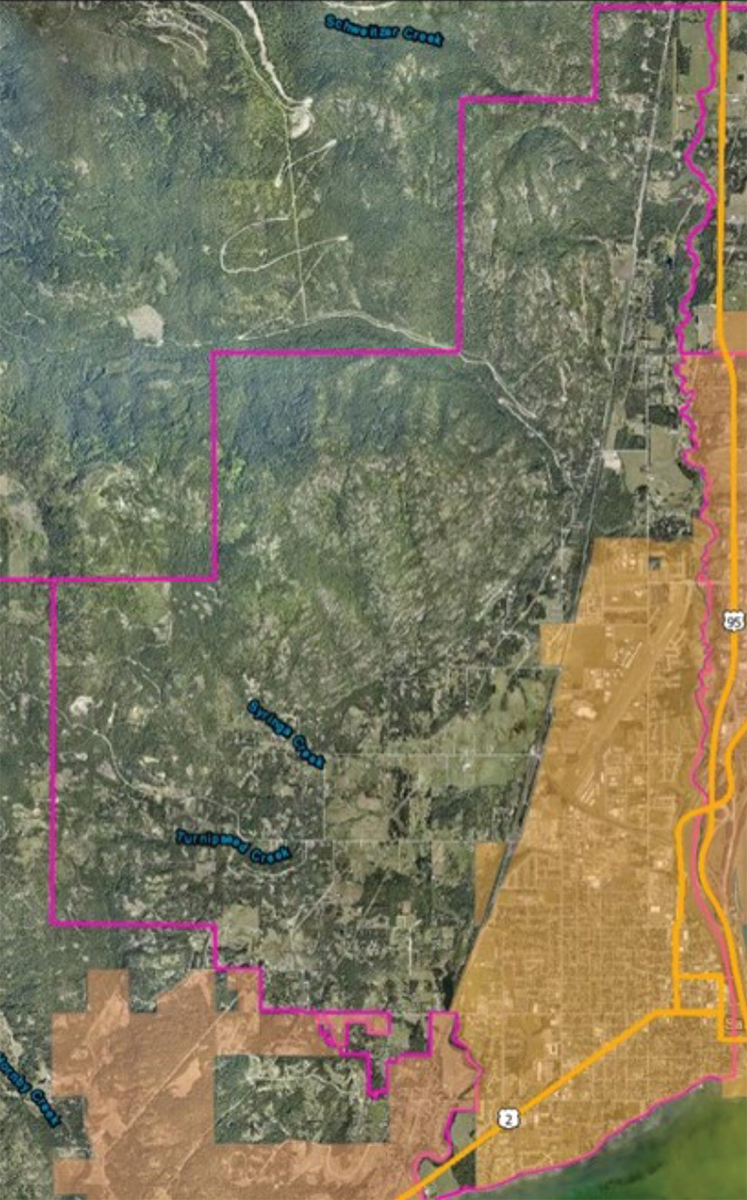
The current Sandpoint area of impact outlined in magenta. Courtesy photo.
Speaking at the May 7 meeting of the council, Welker said much of the land covered in the current area of impact could never be developed with city services “within our lifetimes.” Rather, the proposed reduction — which is about 80% smaller than the present boundary — is intended under the state statute to correspond with areas “very likely to be annexed” in the near future, while Welker said the city’s “ability” to extend services is the more pertinent question.
“What is the city able to serve with utilities and possibly expand into in the near future?” he said.
Howarth questioned how the city would be able to determine the “likelihood” of future annexation, short of polling property owners and gauging their interest in whether or when they’d be interested in connecting to city services. Welker responded that there is no way to know that, and recommended Howarth ask state lawmakers how cities should define the “likelihood” of near-term annexation.
“In my opinion it’s very poor legislation; it’s vague, it’s undefinable to some degree,” Sandpoint Mayor Jeremy Grimm said.
Noting that “99.9% of annexation comes from consent of the property owner,” City Attorney Zach Jones added, “I agree with Mayor Grimm that it’s poorly drafted legislation in that we don’t know what ‘very likely to be annexed’ means. … We can’t do a survey to determine which property owners are hemming and hawing about annexation.”
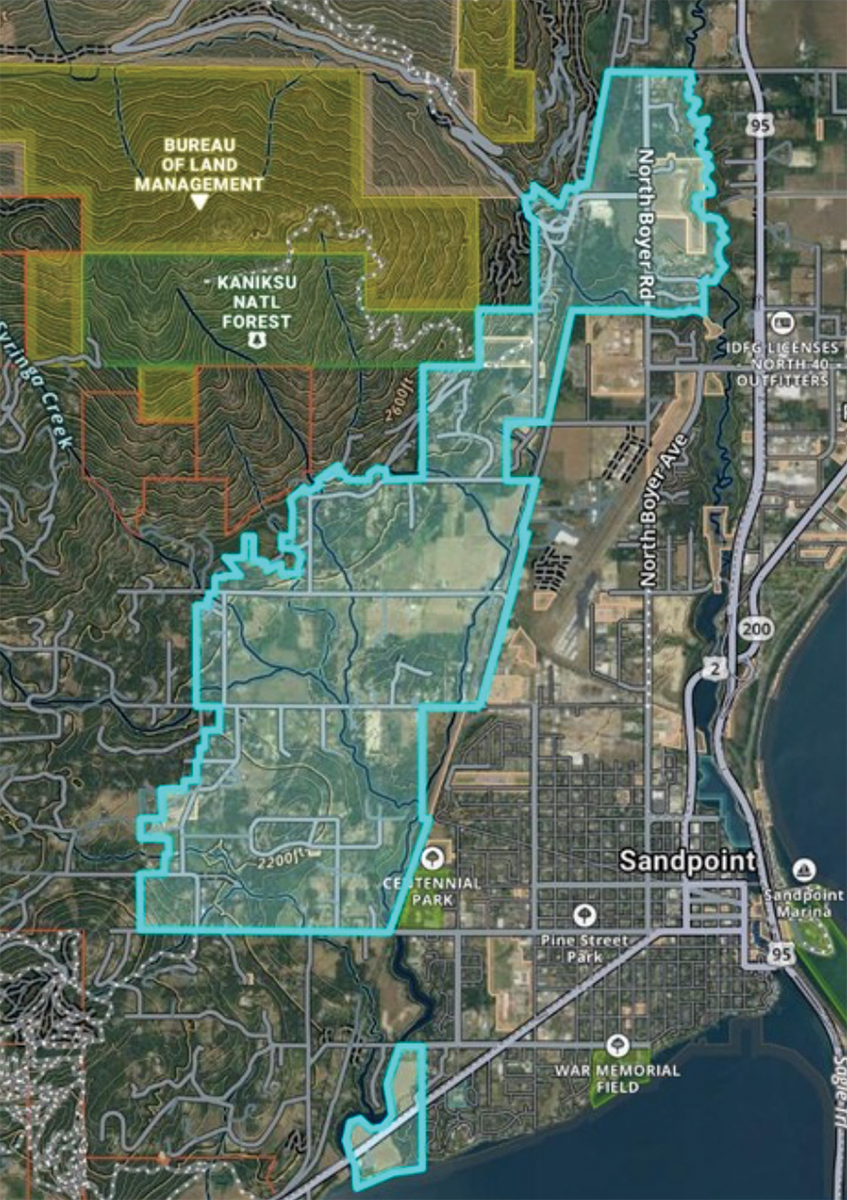
The new proposed area of impact in teal (right). Courtesy photo.
To Howarth’s point about the exercise in boundary drawing being “arbitrary,” Jones said, “This is a legislative decision and it is inherently arbitrary to some extent.”
Pending BOCC’s approval, Sandpoint would redefine its area of impact to run southwest from city limits to vacant agricultural property east of Chuck Slough between Ontario Street and the Pend Oreille River; encompass all properties between Sandpoint’s western city limits north of Pine Street, including both sides of Upland Drive to Baldy Mountain Road; Upland Drive north to Gooby Road; properties along Mountain View Drive to Leisure Lane; then north to Bronx Road and east of Sand Creek — including Woodland Drive, Schweitzer Mountain Road, and the neighborhoods of Sweetgrass Lane and Vedelwood Drive.
All those locations were already within the current area of impact, but the portion including lands east of Chuck Slough between Ontario and the river overlaps with Dover’s own proposed new area of impact.
According to the city’s staff report, planners from Sandpoint and Dover were “unable to reach an agreement regarding which city should incorporate this land.”
At the May 7 council meeting, Grimm said proximity to already existing Sandpoint services makes the most sense, but “[Dover] Mayor [George] Eskridge and I agreed to disagree on this.”
“He thinks this is appropriate to be brought into the city of Dover, so I just frankly disagree,” Grimm added, going on to offer to represent the city of Sandpoint when the proposal goes before the BOCC, and “make a compelling case for why this makes sense to be in Sandpoint’s area of impact.”
Meanwhile, Welker said Sandpoint envisions relinquishing a swathe of property south of Pine Street — including portions of Syringa Heights Road and Ravenwood Drive — “and proposing basically giving that over to Dover.”
Welker said that Sandpoint taking over the Ontario Street area along U.S. 2 “makes sense … given the approximate mile of shared border with city of Sandpoint limits, and there is only a very tiny portion of the city of Dover right along Ontario Street that is adjacent to that property.”
“We’re going to leave it up to the Bonner County commissioners to decide,” he added. “We’re not going to go in there fighting for it necessarily.”
Ultimately, Grimm said, “at the end of the day, I would be very surprised if there is any annexation happening in the rest of my term.”
According to Welker, “the ability to have access to water and sewer just by orders of magnitude increases the land value for properties that are immediately adjacent to city limits right now, so remaining in the area of impact is very much likely in the best interest of some of those property owners if it means they are able to annex into the city in the future.”


 Coming up this week! Don’t miss Live Music, the Summer Sampler, the Art Party, Monarch Grind, the Sandpoint Renaissance Faire, and more! See the full list of events in the